Ben Hai River
Ben Hai River is one of the notable Vietnam rivers as it acted as a demarcation line between the northern and southern zone of the country by the Geneva Accords in 1954. The zone distinguishing the two parts extended about 3 miles from both sides of the river. Located in Central Vietnam, Ben Hai River has a length of about 100 kilometers and it source is from the Annamite mountains. At the broadest point the river is about 200 m wide.
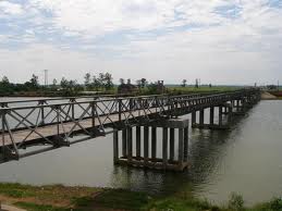
During the period of Partition of north and south Vietnam, a bridge was constructed across the Ben Hai River and was named as Hien Luong Bridge or popularly also known as Hien Luong Bridge. The bridge was built from steel by the French in 1950. Post partition, the bridge was painted in red in the northern side and yellow in the southern side respectively.
During the Vietnam war in 1967 the bridge of Ben Hai River was bombarded by the Americans during the Vietnam war in 1967. Later on after the Peace Accords an entirely new modern bridge was constructed just nest to the previous one and from the very olden days the Ben Hai River is very popular river of Vietnam.
During the Vietnam war in 1967 the bridge of Ben Hai River was bombarded by the Americans during the Vietnam war in 1967. Later on after the Peace Accords an entirely new modern bridge was constructed just nest to the previous one and from the very olden days the Ben Hai River is very popular river of Vietnam.
Tin tức liên quan
- Vietnamese second most confident in Asia-Pacific about post-pandemic travel: survey (24/6/2022)
- Kayaking in Việt Nam’s most beautiful places (24/04/2021)
- Da Nang tops Google list of 10 trending destinations for 2020
- Explore Vân Long Wetland Nature Reserve in Ninh Bình
- Hà Nội Train Street among Top 8 over-touristed sites (03/12/2019)
- VNAT hosts famtrip to explore sea and island tourism products in Quang Nam and Quang Ngai
- Travel Daily News lists amazing ways to see Viet Nam (21/06/2019)
- Ha Noi serves nearly 14.4 million visitors so far (21/06/2019)
- CNN praises Hoi An as one of the most beautiful towns in Southeast Asia (19/06/2019)
- Quang Ninh has additional sea and island tourism site (14/06/2019)
Tìm kiếm
Tour
Hotel
Keyword
Location
Location
Star
Type